

 Oil & Gas
 Maritime
 Power Gen
 Chemicals
 Mining
 Sewers
 Cement
 Nuclear
 Infrastructure

 EN
EN
Choosing the right LiDAR configuration for your Elios 3 starts with understanding the data you need. The standard configuration, equipped with the Ouster OS0-32 REV 6.2 LiDAR, supports visual inspections, navigation, and precise defect localization.
For more demanding surveying projects, the Surveying Package combines specialized hardware and software. The package includes an Ouster OS0-128 REV7 LiDAR sensor to deliver greater accuracy, denser point clouds, and wider mapping coverage, and a choice of two FARO’s SLAM processing workflow.
This article compares the two different LiDAR configurations to help you choose the best fit for your projects. It also explores the two processing workflows, including the 3D Survey Add-On, which enables online processing, review, sharing, and export in Inspector Online.
About the Elios 3 and LiDAR
One of the many things that makes the Elios 3 unique is the fact that it carries a LiDAR sensor. It is the only cage drone in the world to do so, and this empowers workflows in a wide range of scenarios, including confined space inspections, hard-to-access area scans, and 3D surveys.
The role of the LiDAR on Elios 3 has 3 purposes. The first one is stability. The LiDAR is used in complement to the VIO cameras to sense the drone’s movements and compensate for it. This is particularly helpful in extremely dusty environments where visual information is not reliable.
The second one is situational awareness. Whether during data capture through the live map built into the Cockpit app or during post-processing in Inspector, having an up-to-date map of your asset readily available gives another dimension to your inspection work. You can easily understand where the drone is in your asset, helping you navigate to the desired location and return safely to your take-off point. Every point of interest you capture during flight is immediately localized in a 3D model of your asset, helping you connect visual data and a point’s location when back in the office.
The third one is surveying. The Elios 3 uses LiDAR for data collection which is then processed with a powerful SLAM algorithm to create highly accurate and dense point clouds. These point clouds can be used to take measurements, calculate volumes, and analyze an environment in detail.
Surveying Package for the Elios 3
The Surveying Package brings together the hardware, processing tools, and training needed to support your surveying workflow, from field capture to usable 3D point clouds. It includes:
-
Surveying Payload: equipped with the Ouster OS0-128 REV7 LiDAR, available with an Elios 3 drone or as an upgrade for existing users.
-
Processing software: 3D Survey Add-On in Inspector Online, or FARO Connect, a separately licensed desktop solution. Both workflows use FARO’s SLAM processing and deliver consistent accuracy, allowing users to choose between online and desktop processing based on their workflow.
-
Reflective targets: sized for automatic detection during the SLAM registration workflow.
-
In-depth training: covering best practices for data capture, processing, and registration.
Together, the package is designed to improve mapping efficiency, data quality, and ease of processing. Below, we explore the key benefits compared with the standard configuration.
- Greater accuracy: The overall accuracy of the REV7 LiDAR is five to ten times better (up to only 0.1% drift in structured environments) than the one of the standard configurations. This means that models produced by the solution are more true to reality and can serve more demanding applications where centimeter accuracy is required. Results from subsequent testing with the REV7 LiDAR show a clear reduction in drift particularly in the z-axis, with volumetric calculations accurate to within 1% of terrestrial laser scanners.
Almost 5 times more accurate in the z-axis: This z-axis drift factor section shows an improvement in the z-axis going from 3.2% with the standard LiDAR configuration to 0.7% with the Surveying Payload
- Increased mapping efficiency: The REV7 LiDAR has twice as much range (up to 100m) and a point density that is 4 times higher (1.3M pt/sec) than the standard LiDAR configuration. This means users can scan the same volume in a fraction of the time while following simpler flight trajectories. Projects that previously required multiple flights to scan an entire area can now complete data collection in just one pass. Users can now expect to map around twice as much space in the same amount of time.
Twice as much coverage: Side-by-side flights show twice as much coverage with the Surveying Payload
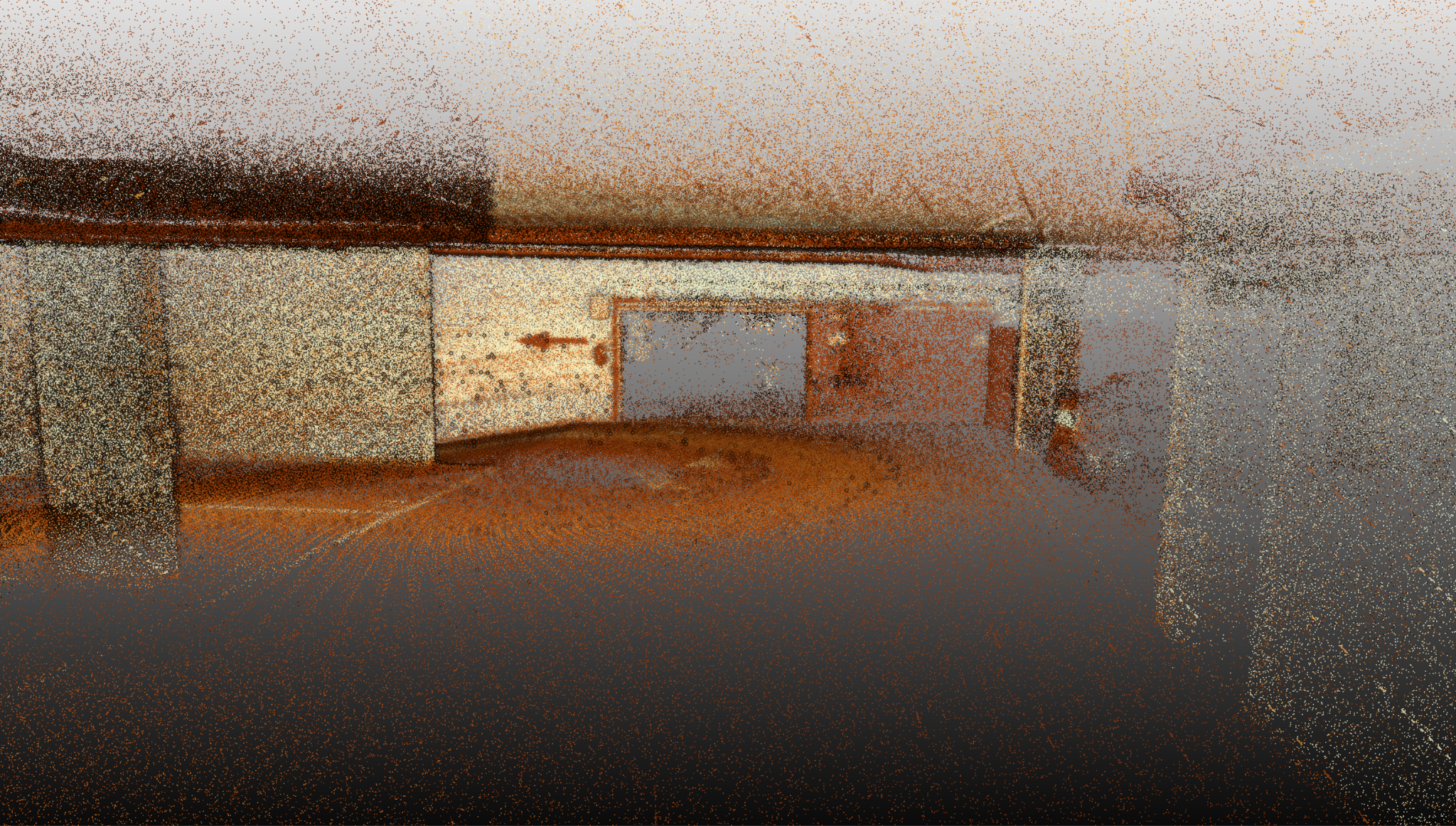
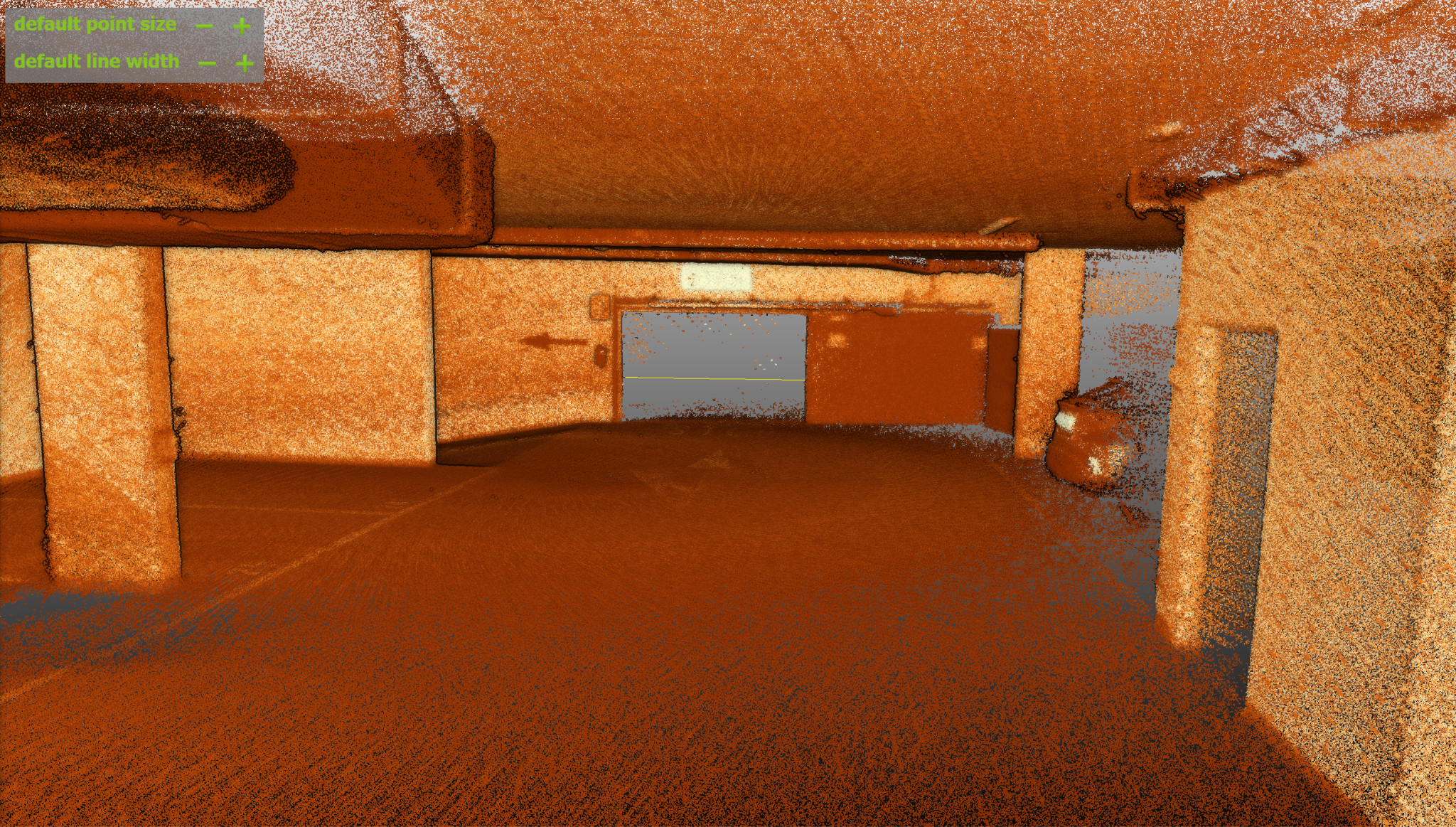
- A whole new level of point cloud quality: The precision of the REV7 LiDAR is 1.5 times better (+/-12mm) than the standard LiDAR configuration and its photon sensitivity is 10 times better. This has a direct impact on the quality and the readability of point clouds. As a result, geometric shapes have sharper definition while the colorization, affected by real-world reflectiveness, is more true to reality. This in turn provides more overall definition to the final point cloud. Overall, the Surveying Payload produces clearer, more detailed point clouds.
Comparison: on the left, the Elios 3 standard LiDAR configuration versus on the right, the Elios 3 Surveying package - Improved robustness in symmetrical environments: LiDAR sensors can struggle to identify points in symmetrical settings, such as pipes or wastewater tunnels, due to the lack of geometrical variation. However, the REV7 LiDAR has greater tolerance for these sites, and as a result, creates better point clouds for projects inside symmetrical structures. The overall accuracy of point clouds of symmetrical environments depends on various factors such as the size and amount of curvature (deviation) in the area but the precision and quality of symmetrical environment point clouds remain unchanged.
This scan with the REV7 LiDAR covers a narrow passage way with pipes running all the way along. Get more information from our accuracy report comparing the standard and Surveying LiDAR configurations
- Streamlined processing: The 3D Survey Add-On brings High-Accuracy Mapping to Inspector Online, streamlining the surveying workflow from processing to export. Survey-grade point clouds can be processed online, reviewed alongside inspection data, shared via a simple link, and exported in LAS format—all within the same environment and without the need for a powerful computer.
Together, these capabilities make the Surveying Package well suited for demanding surveying applications, from underground mines and pipes to confined spaces and complex assets.
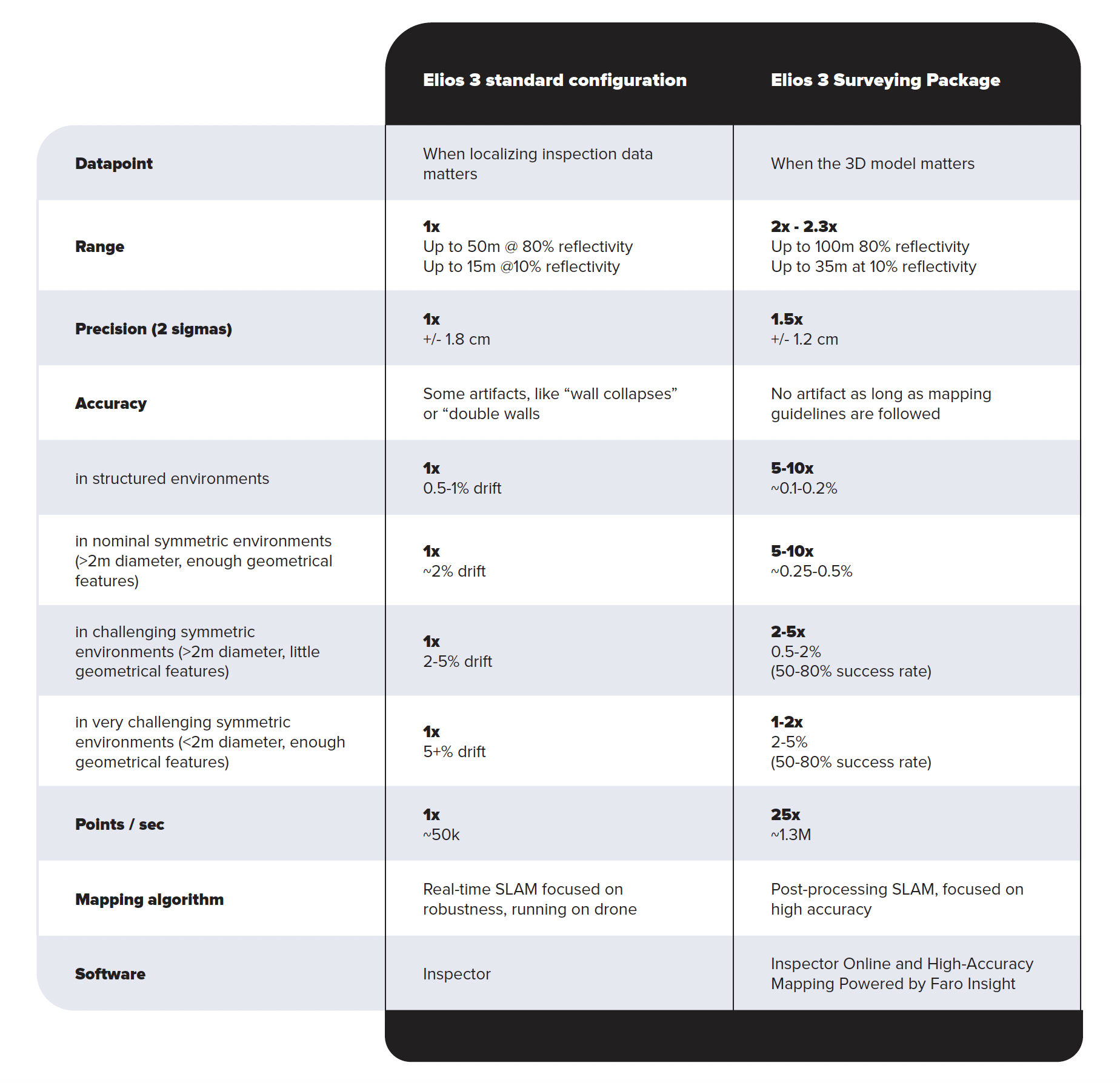
See below the comparison between the technical specification of the standard configuration and the Surveying Package configuration.
Which LiDAR payload is best for you?
The two different sensors present a choice for users of the Elios 3 - which one is best suited for them? It depends on the aims and environment of your project.
Choose the standard configuration (Ouster OS0-32 Rev 6.2 LiDAR) if……
-
Your work revolves around close-up visual inspections of industrial assets. If you essentially want to use LiDAR to help you localize defects and navigate complex space, then the standard LiDAR configuration provides sufficient precision and accuracy to serve your needs.
Choose the surveying package (Ouster OS0-128 REV7 LiDAR with 3D Survey Add-On ) if….
-
You are pursuing centimeter-level accuracy to make important decisions based on geospatial analysis. Typically, your work involves surveying sewer pipes or caves in underground mines, where the terrain may be challenging or you need to survey beyond safe human access. It can also be used to detect physical variations with an order of magnitude of around 1 cm (0.39 inches). This sensor will provide minimal error and comes with software designed to handle its datasets, streamlining your workflows and training to get you started quickly.
To help answer the question of which payload to choose, there are several questions you can answer: what deliverables do you need? Are you looking for a highly accurate 3D model, or simply to gain situational awareness and localize visual data in a 3D model? If it’s the first, you should go for the Surveying package. If it’s the second option, then the standard configuration will support your work exactly as needed.
Still wondering which payload is right for you?
If you have any questions or if you would like to get more information on the capabilities of the Elios 3 Surveying Package, get in touch with our team! We can advise your choice and help you select the best option for your specific needs.