

 Oil & Gas
 Maritime
 Power Gen
 Chemicals
 Mining
 Sewers
 Cement
 Nuclear
 Infrastructure

 EN
EN
High-Accuracy Mapping Validation Report
This report compares outputs from FARO Connect with High Accuracy Mapping, a feature of Flyability's 3D Survey Add-On for Inspector Online. The outputs are compared across representative mission environments, confirming comparable accuracy and precision.
Validation method
The same datasets were processed with High-Accuracy Mapping (HAM) on Inspector Online and FARO Connect on desktop, using identical settings and independent survey references.
- Elios 3 LiDAR captures
- SLAM settings and presets
- Survey targets and alignment
- TLS, total-station, and GNSS references
Results by environments
Structured environment
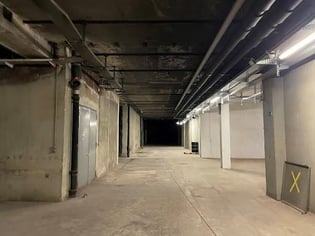
Many distinct geometric features, providing strong references for SLAM processing.
 |
|
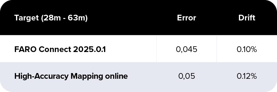
HAM achieved 0.12% overall drift compared with 0.10% for FARO Connect. Both results met the 0.1–0.2% benchmark.
Nominally symmetrical environment
|
|
|
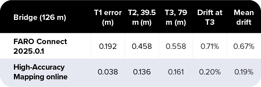
HAM achieved 0.19% mean drift, meeting the 0.25–0.5% benchmark. FARO Connect recorded 0.67%.
At the far target, HAM reduced drift from 0.71% to 0.20% and followed the terrestrial laser scan reference closely along the structure.
Challenging symmetrical environment
Long and repetitive sections with few geometric references.
 |
|
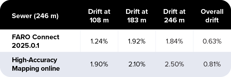
HAM achieved 0.81% overall drift compared with 0.63% for FARO Connect. Both results met the 0.5–1% benchmark.
Drift increased at individual points along the sewer, but the overall result remained within the expected range for this environment class.
Very challenging symmetrical environment
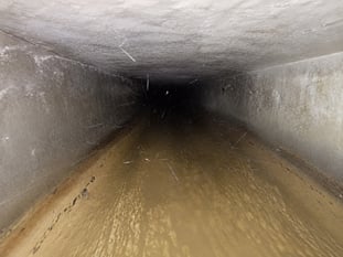
Regular features and bends that help constrain drift.
|
|
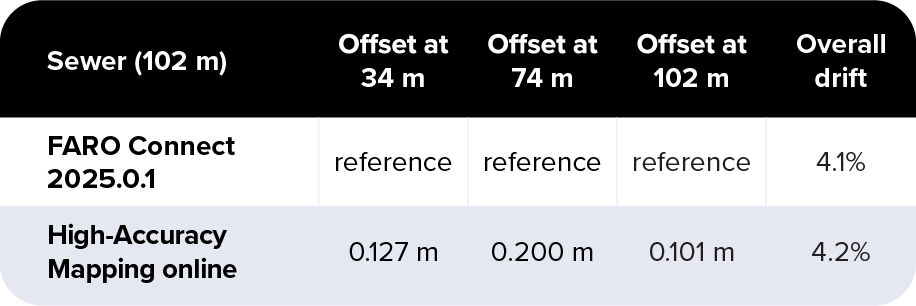
HAM achieved 4.2% overall drift compared with 4.1% for FARO Connect. Both results met the 2–5% benchmark.
The two point clouds differed by only 0.10 m at the far target, with no increasing divergence over distance.
What changes for FARO Connect users
Workflow and available capabilities vary slightly between the two solutions.
|
Software |
3D Survey Add-on |
FARO Connect |
|
Licensing |
Inspector Online add-on |
Separate FARO license |
|
Deployment |
Online |
Offline (Desktop) |
|
Hardware requirements |
Independent of local computer performance |
Dependent on local workstation capacity |
|
Processing |
Unlimited |
Unlimited |
|
User experience |
Unified Flyability interface, viewer, license and account |
Separate FARO software, viewer, license and account | |
|
Sharing/collaboration |
Included with Inspector Online |
- |
|
Data review |
Point cloud and visual data |
Point cloud |
|
Point filtering |
Basic |
Advanced |
|
Georeferencing |
Manual target registration (coming soon) |
Automated GCP target detection |
|
Output format |
LAS |
E57 / LAS / LAZ / PLY |
What remains the same: High-Accuracy Mapping and FARO Connect use the same SLAM processing engine, settings, and presets. Both deliver comparable accuracy and plane-fit precision and produce standard point-cloud outputs for downstream survey workflows.
What changes in the workflow: High-Accuracy Mapping moves processing to the cloud and brings point clouds, inspection data, and collaboration into Inspector Online. It removes the need for a dedicated processing computer and separate FARO software. FARO Connect retains more advanced filtering, automated GCP target detection, and a broader choice of export formats.
Key takeaways✔ Across the four validation datasets, High-Accuracy Mapping met the applicable accuracy benchmarks and delivered accuracy and precision comparable to FARO Connect.
✔ HAM supports moving Surveying Payload processing to Inspector Online when users prioritize online processing, integrated data review, and collaboration. ✔ FARO Connect remains the desktop solution for users who require more advanced processing capabilities. |
